Tierra Plan LLC just launched an interactive map site called the Colorado Springs Historic Map Explorer. We assembled a collection of twenty-four historic maps provided by the Colorado Springs Pioneers Museum and put them online. These fascinating maps are now available in this easy-to-use website for anyone who wants to explore the history and landscapes of the Colorado Springs region. There are all kinds of interesting things to find here.
This site is a contribution to the community. We feel it is important for people to engage in the history of where they live. Tierra Plan is a Colorado Springs company that develops web mapping technology, so we figured we’d do something cool with our technology for the city. Please explore these historic maps, share with your friends, and encourage kids and students to explore. We will add more maps to the online collection as time goes on.
Here’s how it works
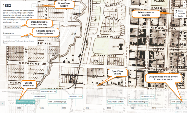
- Open the map site: http://digitaldeepmap.com/cos/
- A timeline with historical map links is located at the bottom. Drag the time line left and right to see the map collection.
- Click the year for a map you are interested in. For example, start with the 1885 Manitou Springs map, it’s really cool.
- The classic Manitou Springs map will appear, and an information window will open at the left.
- Zoom in and pan to observe details in the map. Zoom by double clicking the center of the map, or use the plus/minus control at the upper right.
- Use the transparency slider to compare the historic map to the current map underneath.
- Click Change Historic Map to re-open the timeline and select another map. Or use the tab with the green arrow.
- Change the base map to satellite imagery using the base map tool at the upper right.
How did we do this?
Original paper maps from the museum archives were digitized as part of a larger project called the Story of Us. You can read more about that project here or by contacting the museum. The digitized maps were then georectified by our friends at UCCS. That’s a big word for the process of aligning the original map to a real coordinate system on earth so it aligns with other maps. Next, we tiled every map into thousands of tiny images so they will load quickly when you zoom in and out at different levels (this is same thing Google does with its online maps). We created this website using some of our web mapping technology, a database with information about each map and hosted it our servers for you to enjoy.
Contact us with questions, and enjoy the maps.