Tierra Plan is developing a GIS solution for agriculture field data management built around the ArcGIS platform.
An independent agriculture consultancy specializing in precision agriculture agronomy and mapping services was using a rigid proprietary software system for generating surface interpolations, prescriptions, and treatment zones. In doing so, they have collected an enormous amount of historic field data for hundreds of clients. They are also looking to looking to maximize their investment in ArcGIS and replace their other software with a GIS based solution. While a number of other companies offer field management software for the agriculture industry, there is one common element missing from all of them: users don’t own all their data and cannot easily use it for independent analysis. Data might be the hottest commodity in agriculture right now, this recent article is a good summary.
There are a number of drawback to rigid COTS products for field management:
- They don’t allow independent providers to own all their data.
- GIS data stored internally and nearly impossible to use in other systems like ArcGIS.
- Don’t allow for multi-year, multi-field analysis
- Cost – systems with costs per acre become expensive
- Prescriptions and treatment zones often require significant manual editing
- Too many features and reports that aren’t useful for Crop Focus’ purposes
- Limited spatial analysis and ad-hoc mapping
- There is huge value in owning and analyzing data. Most other solutions and vendors don’t provide the variety of tools for geospatial analysis in ArcGIS.

FIELD ANALYST SOLUTION
Tierra Plan is developing a custom field management solution for an independent agronomy provider built around the Esri ArcGIS platform. Called Field Analyst, it is a scaleable GIS solution for managing and analyzing field data so growers can optimize soil treatments and yields. A suite of ArcGIS desktop tools and web maps lets agronomists and growers manage their soil data, yield, as-applied, EC data, generate nutrient maps, prescription files, management zones, and share data using online maps.
Field Analyst is an affordable alternative to expensive, proprietary systems COTS products. It greatly reduces the time to process and map each farm and field, saving time and money. Agronomists can map more acreage per year and deliver more accurate information. The system includes a complete custom designed back-end database system, desktop tools, web, and mobile user interfaces. A suite of ArcGIS Server map services and geoprocessing services are published for web and desktop users. Users are now free to analyze, report, and map all their historic data without constraints.
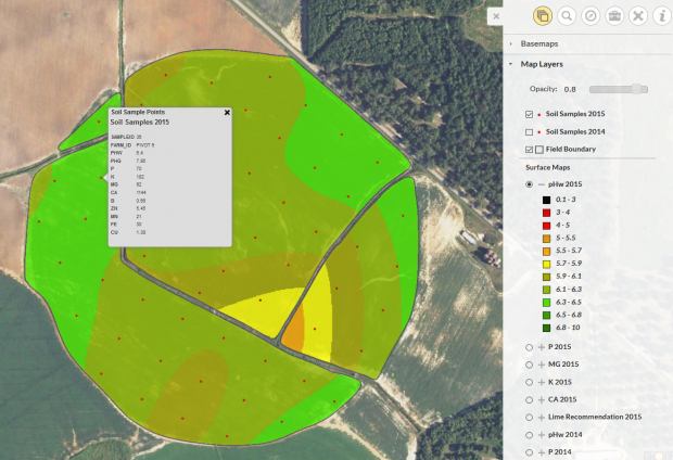
A typical nutrient management deliverable to a grower includes a PDF document with nutrient surface maps for pH, Ca, N, P, K, and Mg; a boundary map showing sample locations with NAIPS imagery; Lime prescription and fertilizer prescription shapefiles used by spreaders to apply variable rate treatment; and an accompanying PDF treatment rate map. This entire process is now generated in Field Analyst and the ArcGIS platform. This offers the most flexibility in creating the surface maps and customizing the final treatment prescriptions, and results can be published to online maps.
Field Analyst Benefits:
- Field Analyst gives growers complete ownership and control of years of data.
- Greatly enhances ability to report and analyze data
- Online maps and tools for sharing data and processing data from anywhere
- Publish field data and maps available online for growers.
- All map data stored in common, non-proprietary, GIS formats
- Custom ArcGIS desktop tools automate the creation of nutrient surface maps, lime and fertilizer prescription shapefiles, and a custom formatted PDF map book for the grower.
- Multi-platform: Field Analyst includes desktop tools, web maps, and we are working on a mobile app developed with the ArcGIS Runtime SDK for Xamarin. https://developers.arcgis.com/xamarin/
- NDVI imagery integration and tools for generating treatment zones from NDVI
- Electrical conductivity (EC) maps
- Create yield maps and analyze yield data
- Easily create management zones from soil surveys, NDVI imagery, and yield data.
- Integration with external data such as:
- USDA NAIPS imagery
- Remote Sensing
- NDVI imagery flown and loaded within 24 hours
- Digital Globe EV commercial imagery. See our Digital Globe EV solution for defense: https://tierraplan.com/2016/04/tap-in-digitalglobe-ev-imagery/
- USDA soil survey data.
- A well designed data model, relational database and storage architecture for all their non-spatial client data, GIS data, and raster surfaces. The database allows easily searching and finding historical data for GIS analysis and reporting; migrating all historical data; supporting a multi-platform interface architecture including web maps, mobile maps, and the desktop tools.
- Web maps allow farmers to view their field data online, including nutrient surface maps, lime and fertilizer prescriptions, yield, as applied data, population maps, NDVI and NAIPS imagery.
- Analyze years of historical data and identify patterns in crop production decisions and inputs vs. yield. Growers can identify patterns such as correlation between yields, and soil nutrients, soil types, varieties, populations, and other crop inputs such as lime and fertilizer particular field year by year.
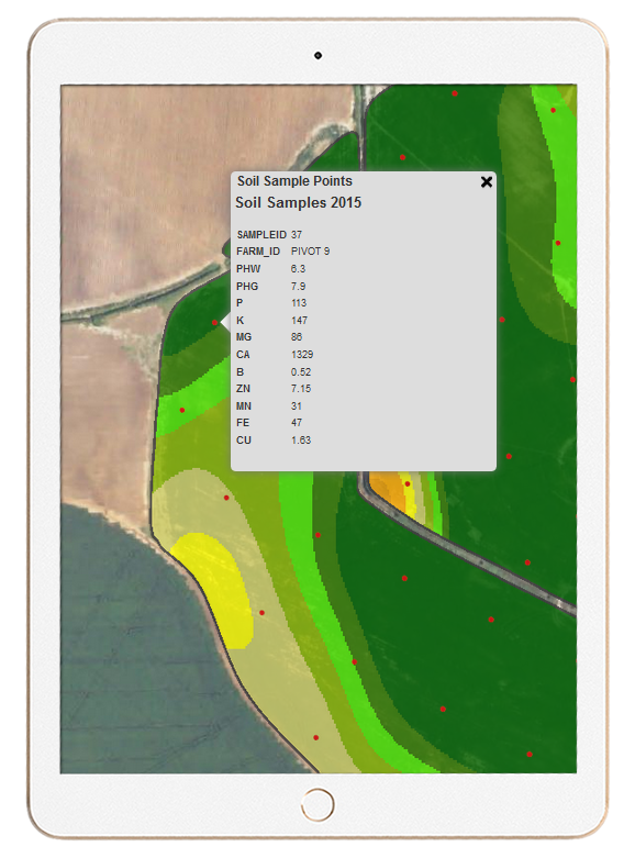
Web based map interfaces allow growers to view fertility maps, download prescription files for Variable Rate spreaders, and more.
Lime prescription treatment map.